
Developing Avalanche Scenario
A major responsibility of a public avalanche forecaster is to look at the weather forecast and assess how it will impact the snowpack and avalanche activity. Another part of the job is to look at forecast weather and assess how it might tie in with human behaviour. I’ve got some thoughts on this weekend’s avalanche scenario and potential trends in human activity; but before we go forward and talk about this stuff, let’s go back and look at the weather over the past month to help us understand the current scenario a bit better.

In the first few days of November most forecast regions had little more than 40cm of snow on the ground, most of which only existed at higher elevations. On November 8th, heavy rain fell to alpine elevations in many parts of the province while subsequent cooling refroze saturated snow surfaces creating a hard rain crust. In many areas, up to 40cm of snow fell immediately after the rain crust formed, but the most critical weather event was the cold, clear spell that plagued the province until last week. The cold temperatures promoted a weakening process called faceting. Facets are those sugary snow crystals that don’t stick when you try to make a snowball. The weather was also ideal for surface hoar development which seemed to be most prominent in locations sheltered from wind and sun. Surface hoar crystals are those weak, feathery looking crystals that shimmer like diamonds when the sun hits them. The tail end of the dry spell saw temperature inversions which enhanced the effect of solar radiation creating moist surfaces on steeper sun-exposed slopes. With more recent cooling, the end result was yet another hard crust adding to an already weak and complex structure that makes up the foundation of our snowpack so far this year. Regions most likely experiencing this (or at least a similar) basal snowpack structure include: the North Rockies, the Cariboos, the North Columbia, the South Columbia , the Purcells, the Lizard/Flathead, and some parts of the Kootenay Boundary and South Rockies .
This weak foundation got buried in most areas on November 20th, and it’s been snowing steadily since. It’s now Wednesday, November 26th, and in some areas the weak basal structure sits up to a metre below the surface, and natural and human-triggered avalanches to size 3 (big enough to destroy a truck) have already been observed. Looking at the heavy snowfall, rising freezing levels and strong winds forecast for tonight and Thursday, I get the feeling the party is only getting started. This weather will, no doubt, deliver a mix of potent, yet relatively short term, surface instabilities. But the load of the new snow (or rain) will also add stress to the weak structure at the base of the snowpack, and may be the tipping point for a more widespread cycle of more destructive avalanches on these deeper layers, which aren’t going away anytime soon.
By Saturday, most of the province will be under a dry ridge of high pressure with cooler temperatures, lighter wind and clear skies. In most areas, natural avalanche activity will likely taper off, surface avalanches should become less frequent, and the warning signs of instability will be likely be less obvious. In some cases Avalanche Danger Ratings may even drop a bit as avalanche activity becomes less likely. But rest assured, those weak layers will be even deeper, the overlying slab will be more cohesive, and avalanches that do occur have the potential to be very large and very destructive.
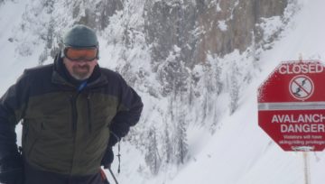
So we’ve looked at the forecast weather, and how it will likely affect the snowpack and avalanche activity. Now let’s look at the human element that has me so concerned. I can’t wait to get on my sled or skis and shred, and I don’t think I’m alone here. We’ve had a slow start to the year, and many folks are chomping at the bit to get into the backcountry and do what they love. The weather for the weekend looks great, lower elevation access is improving, the riding/skiing quality should be pretty much awesome, and social media is priming us with pictures and videos of all the new snow. It doesn’t take long for our motivation to ride more aggressive terrain (and our athletic ability to get there) to overwhelm our mountain sense. This weekend it’s particularly critical that we look at the backcountry with our “avalanche eyes”, and not with our ski, sled, or snowboard movie eyes.
The snowpack structure sounds complicated, but my travel advice isn’t. For the foreseeable future avoid steep slopes (especially big ones), minimize your exposure to overhead hazards, re-group in safe zones away from avalanche run-outs and stick to simple, low angle terrain. This season’s snowpack and avalanche observations have been extremely limited. I expect we’ll learn more about the reactivity and spatial distribution of these deeply buried weak layers over the next few weeks. Until then, I’d assume they’re everywhere there’s enough snow to shred.
Joe Lammers


Comments