
Bugaboos to Rogers Pass Ski Traverse
“Experiences of great intensity — an especial dream, a period of concentrated work, a sudden absorption, maybe a love-affair — have in common that they are unusually real while they last. Yet it is precisely this quality which so easily vanishes. Afterwards, how unreal it all suddenly seems! We lost ourselves in that dazzling fugue whose importance to us we do not doubt and yet which now is so imaginary. Time which seemed not measurable, so endless, suddenly lapses back into the diurnal and leaves behind it disquiet and longing for a lost intensity.”
— James Hamilton-Paterson,
Playing With Water: Passion and Solitude on a Philippine Island (New Amsterdam, 1987)
Bugaboos to Rogers Pass Ski Traverse from Kari Medig on Vimeo.
Like many North American climbers, I have visited some of the classic routes at Rogers Pass and the Bugaboos. Perhaps it was the perennial August snowstorms at the Bugs that convinced me that this area was more suited to skis than rock shoes. Or perhaps it was a remark in a magazine article about the possibility of skiing from Rogers Pass to the Bugs. In any event, it certainly seemed like a fabulous idea, the connecting of two climbing areas via a highlevel ski traverse through remote mountainous terrain.
The route covers a massive amount of terrain, approximately 100 miles with over 30,000 feet of climb; I knew that to do it I would need the help of a guide who was familiar with both the route and safe techniques for winter travel over steep passes. I started making some inquiries. A friend, Richard Guy of Calgary, responded with: “Everyone I know who has tried it has gotten as far as Glacier Circle Cabin at the end of the Illecillewaet Glacier and turned back.” But then he called back, saying, “I forgot. Chic Scott has done it. He’d be an excellent choice.” So I got in touch with Chic and within minutes knew that I had found the perfect guide. Chic was an expert on this sort of ski trip, having done the second traverse of the Rogers Pass to Bugs in 1971, as well as several other even longer ski traverses. His experience in winter mountaineering (first winter ascent of Assiniboine, 1967) and as a climber and guide in Europe, Canada, and the Himalayas was reassuring, especially to one whose winter travel experience was restricted to hut-to-hut tours in sunny Colorado.
Chic is also very knowledgable about the history of ski mountaineering in Canada and he sent me an old Canadian Alpine Journal article about the successful 1958 attempt on this route. I was surprised to learn that one member of that pioneering group was Roberts French of Amherst, Massachusetts. I was living near Amherst at the time and Roberts French, a member of my running club, lived a few miles away. Since there could not be two people with that quirky first name, I knew that my neighbor was a member of the team that first skied the route. In 1958 only the northernmost 20 miles was mapped, and so the party had to rely on aerial photos (which they did not take with them) for planning. The lack of a highway to Rogers Pass was not a problem, however; Bob French recalls: “Our trip took ten days. We had planned on twelve days, and so had two extra days of rations to munch on as we went riding out to Golden in a boxcar with doors wide open. Ah, bliss!”
Chic wanted a second guide for the trip, and again there was a natural choice: Rodden McGowan, who had four years’ experience working with the avalanche control group at Rogers Pass and was currently working as a heli-skiing guide at the CMH Bobbie Burns area. Roddy was familiar with just about the entire route and has had a lot of experience in assessing ski slopes for potential avalanches. The next problem was finding another client. Many climbers are not interested in attempting a project that they could not do by themselves without guides. So I turned to a friend who is more of a backpacker than a technical mountaineer, Tom Whitesides, a chemist from Rochester, New York. Tom had not climbed in Canada and had not skied very much, but promises of a true wilderness adventure with spectacular alpine scenery, requiring little more than trudging 5 to 10 miles a day, lured him into a commitment, though not without some trepidation about what he was getting into.
We chose late April for the trip, with a preparatory get-to-know-each-other ski week at Wheeler Hut at Rogers Pass in January. That week was a wet one as the snow never let up, but we all knew that conditions would be much drier in April. Plans were made to have a food and fuel cache, which ended up being deposited near the head of Malachite Creek.
So, 10 p.m. on April 16 saw the four of us on the one-mile trail heading in to the Wheeler Hut in very clear and dry weather. The following day we took it easy, camping high on the Illecillewaet; many parties push all the way to the Glacier Circle cabin on the first day, but our pace was slow as we got used to our packs (approx. 40 pounds for Tom and me, over 50 for Roddy and Chic). The second day saw the weather deteriorate and occasionally we had to just sit and wait for visibility. But we made it to the cabin without incident, following the winter route down. It follows a wide gully on the west side of this portion of the Illecillewaet; the usual summer route stays closer to Mt. Macoun.
On day three we had to negotiate the cliff protecting the Deville Nevé, a section requiring piton protection and some fourth class rock climbing. Although I had questioned the need for pitons, having done all my rock climbing with nuts and Friends, I quickly became convinced that pitons were the protection of choice here. It took several hours to surpass this obstacle. Indeed, for some parties a major reason in starting from the south end is that the cliff can be rappeled rather than climbed, a choice that minimizes exposure to avalanches off of Mt. Topham.

At this point the weather became generally murky — light snow and low visibility — and progress over the next few days was slow. Several daylight hours were spent in the tent as we honed our chronicide technique. This included reading aloud a Tony Hillerman novel about the Arizona desert, which helped put us in a warm and dry frame of mind. We spent two nights on the Deville before pushing over a col near the summit of Grand Mountain — at 10,350 feet, the high point of the trip. During one late afternoon clear spell we had a tremendous view to the southeast, across the Beaver River to Malachite Spire, all the way to Bugaboo and Howser Spires. They seemed very distant.
But generally the murk dominated and we had to constantly decide whether to push on or wait. Well, “they’ rather than “we”, because of course Chic and Roddy made all the decisions. The group dynamics were interesting, at least when compared to those that occur when a group of equals attempt a climb or ski trip. In that case decision-making is generally by consensus and some friction usually arises when tough decisions have to be made. In our case, though, all decisions were made by the guides. Chic led us spot-on to the Grand Col in zero visibility conditions, relying on the map and his 17-year-old memory of the route. As we descended the other side we realized that we were falling behind schedule and the visibility situation was unlikely to improve. So we headed down the Grand Glacier to the Beaver River rather than going over the high shoulder of Sugarloaf. At one point the visibility was so poor that Chic would proceed by first throwing a prusik sling a short way ahead to give him something to ski toward. We had to proceed very slowly as there were icefalls in this area and one section requried a belayed descent. But we eventually completed the generally pleasant 6,000-foot descent to the Beaver River and even had a few sun breaks to remind us how pleasant travelling in dry conditions can be.
A group from the Kootenay Mountaineering Club completed the traverse three weeks after we did, and Fred Thiessen reported that the Duncan Glacier provided them with an excellent route down to the Beaver River. Another alternative is to push farther south and descend via Butters Creek.
Camp on the Beaver was pleasant as we even managed a fire, but the wet conditions the following morning were discouraging. We didn’t start until 10:00 a.m., setting off briskly in the hope of reaching McMurdo Cabin. A few easy miles through the woods beside the Beaver River brought us to the Beaver-Duncan Divide. This area can be reached from the south by car in the summer and fall, and the KMC group had placed a cache here. Our cache was still several days away, in Malachite Creek.
After the divide we headed up Silent Creek toward Silent Pass. Although the climb was modest compared to some other climbs on the trip, it was especially difficult because of the weather, which continued very wet and snowy, and the constant zigzagging to avoid trees and small cliffs. Silent Pass was a beautiful spot, though it was 6 p.m. when we reached it and we did not linger. We dropped down a thousand feet on the other side to pick up the road heading to the cabin. A roof and warm fire cheered us up as we tried to maintain optimism about the weather, or rather, as we prayed for a few clear days. A rest and drying-out day at the cabin was in order, so we spent our seventh day lolling around the wood stove.
McMurdo Hut is another fine place for a cache, as it can be reached by either snowmobile or helicopter and is the halfway point of the trip. This is an area of some geologic interest, although little rock is visible this time of year. The mining in the region started in the late 19th century and continued on and off until the postwar years when there was a surge of interest by the Beverly Mining Company. David Hope-Simpson (amazing coincidence: he’s my sister’s father-in-law) recalls spending several seasons in McMurdo and Vermont Creeks in the late 40s. The area had some silver, lead, and zinc, though not in great quantity or high grade. Most of the work was exploratory, with little ore shipped out. Nevertheless, the area has high geologic interest and Hope-Simpson based his Ph.D. dissertation on work done there; he also found time for the first ascent of David Peak above the Spillimacheen Icefield.
Day eight had decent weather and we put in a good long day crossing the International Basin at the head of Bobbie Burns Creek and ascending to the Carbonate Icefield. There was one tricky spot near a col where we had to scramble over icy rocks. The night was cold, but we didn’t mind as the first task the following day would be to descend a steep col just east of Malachite Spire. The descent turned out to be straightforward plunge-stepping and we cruised down to a flat spot beside Malachite Creek where our cache had been buried in the snow a few weeks earlier. The murk returned so we stopped early, taking a couple of hours to organize food and gear. We burned what we did not require and gorged ourselves on a fillet of smoked salmon, some Drambuie, and various other goodies.
After the slow going in the Selkirks, we expected that the Purcells would go more rapidly. Yet each day brought surprises. After the cache stop, Roddy led us on a route variation that had not been ascended before, though it had been descended by a party several weeks before us. We climbed to a position below some cornices high on the west side of Mt. Syphax. As the murk returned, Roddy reconnoitred around a corner while we waited . . . and waited. Forty-five minutes later he yelled cheerfully down to us from atop the cornices. Roddy knew that the southwest side of Syphax had a very easy slope — a bunny slope for the heli-skiers. And indeed, after one belayed rock scramble we found ourselves in a great position, close to Syphax’s summit and looking at a very gentle ski run down. We then crossed the basin east of Syncline Mountain and pushed on into the Valley of the Lakes, a very pretty spot.
The next day began with Chic hacking through a cornice at a col across the valley, bringing us to the Snowman Lake area. Here we saw the Kootenay club’s second cache, which was placed by helicopter. Then we descended to the base of the long climb to Hume Pass. This 2,000-foot climb took us to another fabulous high spot. Once again, Chic relied on his memory as he led us 500 feet higher along Deluge Mountain’s shoulder to an easy slope leading to the basin below Climax Col. Now the sun came out in earnest and we enjoyed a relaxing late afternoon hour resting and drying sleeping bags in this west-facing basin, beside an incredible, glaciated face of a shoulder of Crystalline Peak. We had been out for eleven days and were starting to feel that the end of the trek was at hand. All in all, things had not gone badly. Sure, we had lost several half-days to the weather, but there had not been any bad storms. When Chic first did this trip, his group had to wait out a five-day storm high on Sugarloaf in the Selkirks.
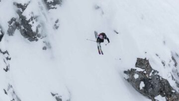
That night, however, the weather turned really nasty, with very high winds. The tent sides were constantly and violently blown inward, and we got very little sleep. By morning the winds had not let up, so we settled in to a ham-and-eggs breakfast and more Tony Hillerman. By about 10 a.m. the winds died down and it looked like travel would be possible, so we packed up and started toward Climax Col, a few hundred feet above us. Soon our skis were off and, as the slope steepened, Chic led ahead while the rest of us followed in his steps a good distance behind. As the three of us neared a rock outcropping I was bowled over by a mass of wet, white stuff — a large slab avalanche had released from Chic’s position, and the whole slope was now accelerating downward. I recall thinking that (a) I was certain my beeper was turned on, and (b) although I can’t swim, I had better do a good imitation. I also knew that the slope below us was free of rocks, crevasses, or trees and so we were not in danger of striking anything. The ride down was in no way painful; after all, the surface of the mountain was moving down at the same speed we were. But there was the fear of the unknown as none of us had any idea of what the situation would be like when friction finally overcame gravity. Fortunately, none of us was totally buried. We looked up at the slope in awe: the fracture line was about 300 yards wide but, mercifully, only about 18 inches deep. We were all quite shaken, especially Chic who, as leader, bore the weight of responsibility for the safety of his clients.
After catching our breath, we inventoried our equipment and discovered that only two hats, one ski, and some poles were missing. We quickly located all but one pole and one hat. Thanks to the sudden removal of the surface layer, the slope to the col was now much safer and we climbed on up, donning crampons for the steep upper portion. Our trauma in gaining this col was rewarded by spectacular views of the two narrow ice-covered ridges coming down toward it from Deluge and Crystalline.
The route down the east side was peaceful, and within a few hours we were camped in the trees at the head of Crystalline Peak. Here we found yet another cache. The route was evidently becoming very popular. As had happened so often, late afternoon brought an improvement in the weather and for the first time we cooked and ate outside the tent. We had been fooled before and so were making no longterm predictions. Nevertheless, the long-awaited clear spell was indeed on its way and our final two days were glorious. We had full sun for the traverse of the Conrad Icefield, so we put in a good long day, reaching the plastic igloo called Shaft Number 7 at the base of Osprey Peak in the Vowell Group. Just before descending to it we had perhaps the best view of the trip: all the way north, past Malachite Spire to the Bishops Range and the peaks near Glacier Circle; and a stone’s throw to the south, the welcoming finish post of Bugaboo Spire.
The next day (the final day: our fourteenth) we passed through Bill’s Pass and crossed the Vowell Glacier, which was free of crevasses. I recalled how in summer this glacier is a broken-up mess. We followed heli-skiers’ tracks to the Bugaboo-Snowpatch col and found the descent easy, with the infamous bergschrund of summer completely filled with snow. We all felt tremendously satisfied as we glided down the Crescent Glacier in the shadow of Snowpatch Spire. Somehow two days of glorious weather was more than enough to make up for the mist that dominated the trip.
The ski guides at Bugaboo Lodge had known about our trip and had been following our progress that day. Because a helicopter was going out that evening to pick up a band for a party, they wanted to be sure we reached the CMH Lodge in time to catch a ride. Just as we reached the bottom of the Bugaboo Glacier, about a mile from the lodge, a helicopter landed and we were whooshed to the comforts of the lodge. Culture shock, but we weren’t complaining! After a few beers courtesy of curious heli-skiers, we were treated to a scenic helicopter ride back to Roddy’s truck and soon we were at The Mad Trapper in Golden, amazed at how easy it was to settle in to civilized habits. Little did I know that the crux of the trip was still ahead: eating vinegar-flavored potato chips with sunburned lips — a rare treat, Chic assured me.
The traverse lived up its reputation for remoteness, adventure, and fabulous scenery. If the popularity of the route today is any indication, it looks like a lot more people will be enjoying this skiers’ Haute Route in the future.
by Stan Wagon
This article appeared in the Canadian Alpine Journal
REFERENCES
Roberts French, Canadian Alpine Journal, 1960, p. 76.
Roberts French, “Skiers travel 100 miles across mountain ranges”, Summit, vol. 5, Jan. 1959, pp. 6-11.
Chic Scott, “The great Canadian high level ski tours”, Canadian Alpine Journal, 1978, pp. 2-4.


Comments